Dream team: GIS and supply chain management

Mapping out opportunities for geospatial data: GIS software and supply chain management tools go hand in hand.
|
Getting your Trinity Audio player ready...
|
Organizations are using geodata in a wide variety of ways to understand more about their assets and improve operations. And the pairing of geographic information systems (GIS) and supply chain management provides multiple examples of how firms are profiting today from knowing what’s where and when.
How GIS adds value to supply chains
GIS can be pictured as large databases for capturing, storing, and analyzing spatial information. One of the beauties of running raw data through GIS is how patterns, which would be lost in a spreadsheet, come to life on a map. Given the visual appeal, it’s easy to see how GIS adds value to supply chain dashboards. What’s more, the plus points run both ways.

For example, Intel-owned Mobileye – a developer of automotive cameras, as well as other advanced driver assistance technology – has partnered with multiple organizations to expand on the benefits of geodata. In Mobileye’s case, the primary functions of the integrated cameras are vehicle-based, but that’s by no means all that can be achieved using the data.
From a GIS and supply chain perspective, having a huge number of vision systems on the road at all times makes mapping tasks a breeze. Dubbed Road Experience Management (REM), Mobileye uses the power of the crowd to constantly update its database of highly precise, high-definition digital maps.
Check out the newest video in our #ArcGISProShorts series to learn how to edit line features using the Extend or Trim tool in #ArcGISPro!
Recorded by: Valeria Chavez (@Valeria030999)
Watch the video:https://t.co/kW3NOtHSKR pic.twitter.com/ZTBiWnaivr
— ArcGIS Pro (@ArcGISPro) October 20, 2023
Putting the setup through its paces, the team mapped all of Japan’s major roads, which cover around 25,000 km, in just 24 hours. The system can digest not just navigation details, but also help utilities firms to keep track of roadside infrastructure. In the UK, water companies have trialed the technology to improve the alerting of leaks and pipe breakages.
Tesla uses neural networks to recognise water droplets and spray on the windscreen of its electric vehicles, in order to activate wipers automatically. And the feature hints at another way of how information can flow back and forth, improving GIS and supply chain management in tandem.
Crowd-sourced weather alerts
Weather apps have come on leaps and bounds thanks to predictions made using supercomputers capable of running ensemble models, which combine multiple forecasts into one. But nothing beats being able to look out of the window for up-to-the-minute weather accuracy, and transport operators can now leverage GIS for a local perspective no matter where they are.
Harnessing the power of the crowd, Lytx – a maker of fleet safety solutions – recognized the potential of dash cam images to provide real-time weather warnings. US Federal Highway Administration weather-related crash statistics report that over a fifth of annual road traffic accidents (more than 1.2 million crashes) occur in adverse conditions.
Lytx presented its vision-based Weather Hazard Alerts feature, which overlays NOAA weather warnings (including snow, thunderstorms, floods, and tornados – to give a few examples) onto fleet maps, at the recent American Trucking Association Management Conference and Exhibit held in Austin, Texas.
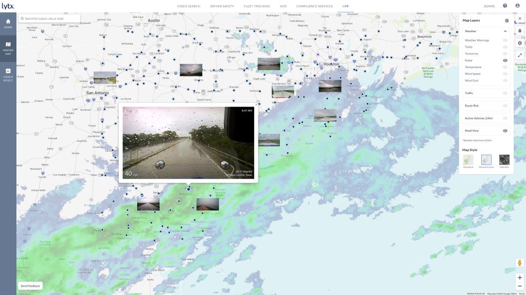
Real-time, through the window weather warnings thanks to the power of the crowd and GIS. Image credit: Lytx.
The application of machine vision and AI to identify adverse weather in imagery gathered by vehicles enables highly localized weather alerts. And Rajesh Rudraradhya, CTO at Lytx, views the tool as a key element in being able to proactively reduce the number of accidents on the road.
On TechHQ, we’ve written previously about how data providers support the needs of logistics firms. For example, Trimble – whose solutions span a range of sectors from agriculture to supporting government agencies – can alert road transport clients to whether routes are likely to feature low-hanging branches.
Having this level of detail can make the difference between high-value cargo arriving intact or suffering unnecessary and – in the case of luxury cars on the top deck of a vehicle transporter – costly damage.
Carbon planning
Understanding where trees are points to some of the wider uses of GIS beyond supply chains. GIS capabilities help organizations to scale their carbon planning activities efficiently. What’s more, the latest tools don’t just make sense of rich data sources such as aerial photography, they can help distribute that information across the organization, making it available to all stakeholders.
Waterford City and County Council in Ireland has a goal of reaching 20% tree coverage across its administrative area to enhance biodiversity and deliver other environmental benefits to inhabitants. But hitting that target means quantifying how many trees there are currently in the region – a laborious and cost-prohibitive task if performed manually.

However, GIS can help to reduce the workload considerably. In Waterford’s case, they opted to use Safe Software’s FME platform to integrate the data. The fruits of that work, which includes contributions from geospatial data experts Bluesky International, can be seen in the Waterford City and County National Tree Map.
The data reveals tree locations (and assigns each a unique id) as well as canopy size and height estimates, and – highlighting the role of tools such as FME – all of this information can be integrated into other planning systems. For example, the data can pinpoint areas ideal for new tree planting as well as guiding strategies for future developments and land use.
GIS in combination with other operating data is a powerful tool for organizations of all kinds, whether that’s companies looking to optimize their supply chains or agencies wanting to improve the health and wellbeing of their surroundings. GIS day, which takes place on 15 November, 2023, recognizes the fact that every map has a story to tell. It’s the ideal opportunity to discover more about how geodata can help us understand our world and make better decisions. And, naturally, there’s a map so that you can find a local event that’s happening near you.

5 March 2024