Going the extra mile with vehicle data
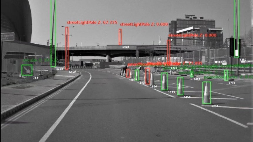
Infrastructure mapping: tagged image gathered from a front-facing vehicle camera. Image credit: Mobileye, an Intel Company.
Driving data from dashcams, GPS transponders, and engine management systems provides rich pickings for all kinds of stakeholders in ways that you may not be aware of. Mobileye, which has been owned by Intel since 2017, has been quick out of the blocks on squeezing the most out of its camera imagery. Achievements include mapping Japan’s 25,000km road network in just 24 hours and helping utilities companies in the UK monitor their roadside assets by running data through machine vision algorithms capable of identifying network boxes, telegraph posts, manhole covers, drainage grates, and more.
Projects in mainland Europe include camera setups fitted to buses, street cleaning vehicles, and police cars, which are helping Barcelona’s municipal services to make city streets safer for everyone. Dubbed ‘Shield+’, the system provides visual and audio ‘blind spot’ alerts to drivers – warning when a pedestrian or cyclist, for example, is close by, but out of view of the vehicle’s mirrors. And, smarter still, the alerts can be aggregated across the urban area to generate a map of incidents and identify any dangerous hot spots. This information is then used by the city council to make improvements to their infrastructure and road layouts.
Mobileye’s units have long been used by carmakers to provide driving assistance services such as lane-keeping and cruise control, but even early on it was clear that there was so much more that could be done with the data being generated. The vision hardware itself has also grown in sophistication, evolving from a relatively simple front-facing setup mounted above the vehicle’s rear-view mirror to an 11-camera configuration offering hands-free driving, automated parking, and automatic preventative steering and braking. The latter submits micro-manoeuvre requests to vehicle controllers to smooth the motion of the automobile and correct for unsafe driving.

Wisdom of the crowd
More than 300 new car models, across a range of manufacturers, feature some kind of Mobileye camera. Systems can also be retrofitted, which together amounts to millions of ‘eyes’ on the road. And by crowdsourcing the views – stripped of identifiers to anonymize drivers – the company can rapidly generate road maps that update in near real-time and map transport networks incredibly quickly.
Recruiting driving assistance cameras as roadside mapping volunteers has completely changed the economics of cartography, and famous names such as the UK’s Ordnance Survey are excited by the prospects that this crowdsourced data opens up. Connected and autonomous vehicle providers are coming onboard too as it changes the way that they can build the maps necessary for self-driving cars to find their way from A to B.
Rather than spending months driving an expensively equipped vehicle bristling with LiDAR, radar, a host of other sensors, and a trunk full of computing hardware; self-driving companies can instead piggyback on the journeys made by millions of drivers every day. And, to minimize bottlenecks and keep data flowing, Mobileye has trained its algorithms to cherry-pick the information sent to the cloud. This keeps the data overheads low – around 10 KB per car per kilometre, according to the firm – which, critically, means that dynamic mapping data can be uploaded over a 3G connection (via the vehicle’s built-in cellular modem) and doesn’t have to wait for the arrival of faster 5G infrastructure.
YOU MIGHT LIKE

The Power of the Community in Cyber Defense, with Synack
Hardware add-ons
Well aware of the value of crowdsourced maps to the growth of the autonomous vehicle sector, the firm’s engineers have developed ‘turnkey’ hardware to make it more straightforward to add self-driving capabilities to vehicle designs. French-based mobility solutions provider Transdev is just one of many firms that are collaborating with the Intel-owned company, in this case on a project to develop and deploy autonomous shuttles, which began in 2021.
Easy-to-add hardware combined with innovative add-on services are making a big difference across the automotive domain – for example, telematics provider Verizon Connect has an AI-powered video classifier that works with dashcam footage. The application automatically grades events such as harsh cornering, acceleration, and braking, so that fleet managers can quickly respond to incidents without having to trawl through hours and hours of video.
Fertile ground for ideas
Once gathered, roadside data can be mined for a wide gamut of uses. Mobile mapping specialist Cyclomedia, headquarted in The Netherlands and with offices in the US and Germany, is working with electricity providers to pinpoint where vegetation is encroaching on transmission cables. Tagged and available in the cloud, the images allow utilities companies to focus on problem areas and save time by eliminating unnecessary patrols and inspections. Remediation can be carried out safely and efficiently before any of the issues become critical.
Shipments of connected cars are on the rise, with automotive cloud platforms such as those offered by Ericsson and others are serving millions of vehicles across more than 150 countries. And, as we’ve been discussing here, the prospects for crowdsourcing data from mobile nodes and then turning that information into new innovative applications are huge.


20 June 2024