Satellite data puts global food basket on the radar
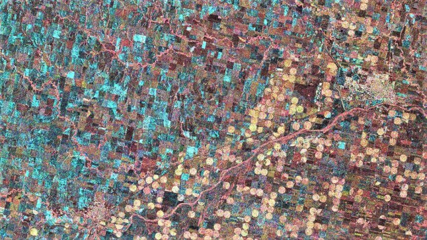
Wheat state: radar image of Kansas gathered by NovaSAR-1, which features an SAR payload. Image credit: SSTL.
If you live in the countryside and stroll past rows of fields every day, you’ll have a good idea of how this year’s harvest is coming along. To see a bit further, you could launch a drone and gather some useful data. But imagine if you could capture crop data globally, and then set artificial intelligence algorithms to work on dynamically mapping the world’s food resources? Planet Watchers, a big data specialist focusing on providing global agricultural intelligence, is one example of a technology firm doing just that by tapping into one of the biggest trends in satellite imaging – synthetic-aperture radar (SAR).
SAR bounces energy in the microwave and radio portions of the electromagnetic spectrum off the earth’s surface and measures how it’s scattered by features on the ground. “Differences in surface roughness are indicative of field plowing, soil tillage, and crop harvesting, “writes Ricardo Rendon Cepeda of the Center for Strategic and International Studies – a US think tank based in Washington DC. “[And] differences in surface reflection can help distinguish heavy flooding, light flooding, urban areas, and permanent bodies of water.”
What’s more, changes in measurements over time can reveal sinking ground – for example, where resources have been extracted below. Data can also distinguish between wet snow and dry snow, and all of these features can be seen regardless of cloud cover or time of day conditions – aspects that hamper passive optical satellite imaging.
Eyes in the sky
Of particular interest for agricultural monitoring, are spaceborne SAR systems that operate in the so-called S (2-4 GHz), L (1-2 GHz), and P (0.3 – 1 GHz) bands, which are well-suited to biomass and vegetation mapping. Upcoming examples include NISAR, a joint Earth-observing mission between NASA and the Indian Space Research Organization (ISRO), which is scheduled to be launched in 2023. Incredibly, the technology has the potential to detect changes in our planet’s surface less than a centimeter across. Other projects worth keeping an eye on, include Japan’s ALOS-4 mission and Germany’s Tandem-L (with a provisional launch date of 31 Dec 2024).
In 2020, ICEYE – a Finnish satellite company, which evolved out of CubeSat research performed at Aalto University – demonstrated 25 cm resolution using its commercial SAR satellite constellation. The technology, as the company explains, “Can provide data on any location on Earth, day or night, through the clouds and multiple times per day.” Other operations include Capella Space, PAZ and TerraSAR-X. But it’s worth noting that in many cases, constellations feature the more general purpose X-band SAR. In 2018, Surrey Satellite Technology released first images gathered by NovaSAR-1, which features an S-band SAR payload. And L-band missions currently in orbit, include the Japanese ALOS-2 [PDF – in Japanese and English] and Argentinian SAOCOM projects.
SAR is a deeply fascinating topic, and there are even open-source Python libraries for pulling out imagery from a range of satellite sensors, including optical and SAR. And to find out more about the features of interest in the agricultural sector, it’s worth cycling back to Planet Watchers, who have some great ideas on the opportunities that SAR information unlocks.
Data insights
To help with yield modelling, the company is able to provide time of planting information within just two weeks of the crop being planted. Advanced machine learning algorithms can monitor the stability and disturbance of soil for clues that point to planting dates and the size of the area that has been seeded. By eight weeks of growth in the field, the firm’s trained models can classify crops with high levels of accuracy (97% according to Planet Watchers). “Optical imagery alone can only provide this information at a much later stage of growth and is continually impeded by the presence of clouds,” writes the company in its technical notes.
READ NEXT

Smart tech for the 15-minute city
Considering other useful measurements that come easy to SAR, wind damage to crops can be graded as either low, medium, or high, by assessing changes in vegetation heights that indicate whether plants have been slightly bent or tipped, highly bent or tangled, or completely flattened. The recording of time-series data opens the door to identifying a wide number of trends and historical features such as the occurrence of flooding.
Organizations working with Plant Watchers include crop insurance firm ProAg, fertilizer company Nutrien Ag Solutions, The World Bank, and the US Environmental Protection Agency. And this week, Plant Watchers announced that it had raised $11 million in series A funding to fuel its growth plans. In 2021, the company announced $3.5 million of pre-A round backing, which highlights the momentum behind the power of big data to boost agricultural insights.
Other agricultural intelligence companies active in the satellite imaging scene include Farmers Edge, which has sites in the US, Canada, Australia, and Brazil. Features of the firm’s software, which gathers insight from layers of satellite imaging, include the ability to send notifications to mobile phones and other smart devices when changes in crop health are detected.

5 March 2024