OS drone mapping will collect data for UK businesses
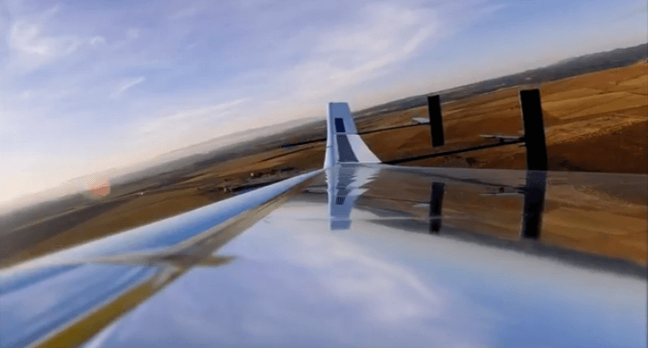
View of the wing of an Astigan aircraft. Source: Ordance Survey / Youtube
The UK’s Ordnance Survey (OS) mapping agency is set to launch a solar-powered drone to capture high-quality images of the earth.
Businesses and organizations will be able to use the images and data it collects.
The technology will come courtesy of Somerset-based Astigan— of which OS owns 51 percent— which builds its drones in the former factory of Facebook’s abandoned Aquila internet drone project.
The aircraft itself has a wingspan of 38m and weighs just 149 kg— it can circle the Earth for up to 90 days before needing to land, and can reach altitudes of 67,000 ft (20,400m), or roughly twice that of a commercial airliner’s cruising altitude.
The drone is actually a High Altitude Pseudo-Satellite (HAP) which complements existing satellite services and, as noted by ITPro, is “more of a platform than a single entity”.
According to OS, existing satellite services which orbit the earth do not provide sufficiently high-resolution detail for its maps. The Astigan drone, however, is controlled from the ground and can be directed to large areas of interest.
“Our current mapping capabilities are driven by two efforts,” explained Neil Ackroyd, acting chief executive of Ordnance Survey told the BBC.
“One is using fixed-wing aircraft to take photos for our revision programme. Then we have our field surveyors on the ground, supported by data from local authorities and the land registry.
“What the Astigan project does is gives us the capability of using aircraft, but quicker and at a significantly lower cost.”
Astigan, a solar-powered, pseudo-satellite designed to observe the earth from 12 miles high. It’s being developed in this hangar in Bridgwater by a team including balloonist Brian Jones. pic.twitter.com/i5C5YQQ2K4
— Anthony Ward (@Anth0ny_Ward) February 12, 2019
Images and data will be accessible for use in commercial and industrial applications— so will be unlikely to appear in the public domain within services such as Google Maps— while the platform will be made available to companies that want to attach their own cameras or sensors.
“The UK has a particularly successful track record in mapping and associated technology,” said the UK’s Business Minister, Lord Henley.
“This exciting new unmanned aircraft project is a brilliant example of the innovative thinking behind our modern Industrial Strategy and should lead to global business opportunities.”
YOU MIGHT LIKE

New tech will provide detailed maps for UK business
Lord Henley added that as well as supporting government objectives, such as upgrading UK key infrastructure, the project could benefit emerging areas such as smart city and self-driving vehicle technology, which both rely on accurate 3D mapping.
OS also wants to extend the drone technology to the mapping of countries or regions which can’t afford ‘traditional’ mapping services, because of the cost or scale of their geography.
But the platform’s cameras, atmospheric monitoring systems, and multi-spectral sensors could have diverse and valuable applications, including in climate and environmental monitoring (such as monitoring polar ice caps or deforestation); providing early warning, observation and communications over natural disasters; and supporting land management and urbanization challenges across the world.
On any privacy concerns, OS added that the nature of the platform’s photography (at such height) generally makes it difficult to identify people from the images, much like existing satellites.
“It’s hard to see people vertically, as you can only see the top of people’s heads,” said Ackroyd.
So far this year, the mapping agency has seemingly doubled down on efforts to advance its services with cutting-edge technology.
Last month, Ordnance Survey teamed up with Intel-owned automotive camera-based mapping company Mobileye with the aim of bringing high-precision visual location data to UK agencies and businesses across energy, infrastructure, and other sectors.
Utility companies, for example, could use the service to maintain the precise location of their assets on the ground, such as manhole covers, lamp posts, telephone poles and more.
The sizable volumes of location data on road networks and roadside infrastructure collected through the partnership is expected to “bring us closer to the realization of smart cities and safer roads”, said Mobileye’s CEO, Amnon Shashua.

20 June 2024